
Where to Find the Seattle View You Actually Want
Kerry Park gives the classic Space Needle-and-downtown view, with Mount Rainier only sometimes visible. Compare free parks, a ferry and ticketed decks.
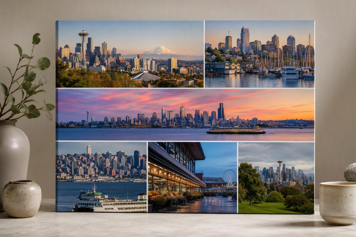
Seattle does not have one definitive skyline angle. The city looks substantially different from Queen Anne, Lake Union, Elliott Bay, West Seattle, a moving ferry, or an observation deck. Even the Space Needle changes roles: from some viewpoints it dominates the foreground, from others it becomes a small marker among downtown towers, and from its own observation deck it disappears from the composition entirely.
That variation makes choosing easier once you stop trying to collect every famous view. Decide what you want the scene—or the experience—to contain. Then choose one skyline stop around that goal, accounting for cost, travel time, weather, and the rest of your day.
Choose the skyline composition before choosing the viewpoint
Depending on where you stand, the frame may also contain downtown towers, Elliott Bay, Lake Union, ferries, stadiums, port infrastructure, retained industrial structures, or Mount Rainier.
Those elements do not align equally well from every direction. Kerry Park produces the familiar relationship between the Space Needle and downtown. Gas Works Park spreads the city across Lake Union. West Seattle puts Elliott Bay between the viewer and the towers. A ferry replaces a stable panorama with a changing water-level view. An observation deck reveals streets, rooftops, neighborhoods, and surrounding water from above.
The options fall into five useful categories:
- Classic Space Needle-and-downtown composition: The Needle stands prominently in front of the central skyline, with water and possibly Mount Rainier adding depth. Kerry Park is the standard choice.
- Lake Union panorama: Water occupies much of the foreground, and the city forms a broad horizon rather than a compressed cluster. Gas Works Park supplies this composition.
- Elliott Bay waterfront panorama: Downtown is seen across the bay, emphasizing the waterfront and the city’s relationship with the water. Alki Beach is the clearest supported example.
- Moving water-level view: The skyline changes as a vessel leaves or approaches downtown. A Washington State Ferries crossing can provide this experience on a Bainbridge Island outing.
- Elevated city panorama: Streets, towers, water, and distant neighborhoods become part of a high, wide view. Smith Tower and Sky View Observatory can retain the Space Needle within the wider scene.
The central Space Needle tradeoff is simple: ascending the landmark gives you height and the experience of being inside it, but you cannot include the tower itself in the resulting skyline photograph. If the Needle is the subject, choose an outside viewpoint. If entering the landmark matters more than keeping it in the frame, its observation deck may be the better fit.
For a quick selection:
- Choose Kerry Park for the recognizable postcard-style relationship between the Space Needle and downtown.
- Choose Gas Works Park for Lake Union, a wide city horizon, and industrial foreground character.
- Choose Alki Beach for downtown across Elliott Bay.
- Choose the Bainbridge Island ferry for movement, changing angles, and a water-level departure from the city.
- Choose Smith Tower or Sky View Observatory for height while retaining the Space Needle somewhere in the wider view.
- Choose the Space Needle when entering the landmark matters more than including it in your composition.
None is objectively best. The practical choice depends on whether you want an iconic photograph, an unhurried park visit, a ferry outing, or an indoor ticketed experience. Budget, available time, weather tolerance, and starting neighborhood matter as much as the view itself.
Seattle skyline viewpoints at a glance
This comparison organizes the main experiences by composition rather than ranking them. “Sunset,” “blue hour,” and “night” are commonly recommended periods, not guaranteed or universally superior conditions.
| Viewpoint | Viewpoint type | Defining elements in the scene | Space Needle visible? | Cost category | Commonly recommended time | Principal planning caveat |
|---|---|---|---|---|---|---|
| Kerry Park | Compact neighborhood park viewpoint | Space Needle in front of downtown; water; Mount Rainier possible | Yes—prominent | Free outdoor viewpoint | Sunset, blue hour, night; sunrise is also recommended | Mountain visibility is uncertain; approach may be uphill; parking and crowd reports vary |
| Gas Works Park | Large outdoor park across Lake Union | Lake, broad skyline, Space Needle, retained industrial structures | Yes | Free outdoor viewpoint | Sunset through night | The composition is wider than Kerry Park’s; verify current park access |
| Alki Beach | Stationary waterfront view | Elliott Bay, downtown towers, waterfront activity | Depending on exact position and visibility | Verify current public access conditions | Daylight, sunset, blue hour, or night | Requires travel to West Seattle; confirm current transportation |
| Bainbridge Island ferry | Moving water-level view and transportation | Downtown, waterfront, port facilities, stadiums, Space Needle | Yes, with changing scale and angle | Transportation fare | Daylight through evening | Check the current schedule, fare, terminal information, and service alerts |
| Smith Tower | Elevated observation experience | Downtown streets, nearby buildings, water, architectural interior details | Yes, including a northward view between buildings | Ticketed | Daylight, blue hour, or night | Check current admission, hours, access rules, and visibility |
| Sky View Observatory | High indoor panoramic viewpoint | Wide city panorama from a 73rd-floor viewpoint; water and neighborhoods | Yes | Ticketed | Daylight, sunset transition, or night | Weather can reduce the benefit of the greater height; check entry and access details |
| Space Needle | Landmark observation experience | Elevated views over Seattle and surrounding water | No—the viewer is inside it | Ticketed | Any period suited to the desired light | The tower cannot appear in your skyline composition; compare current entry rules and prices |
Travel reporting supports classifying Kerry Park and Gas Works Park as free outdoor viewpoints and the major observation attractions as paid experiences, but historical blog prices should not be used for budgeting. Confirm current admission and access before leaving or buying a ticket. Miss Rover’s viewpoint guide provides the underlying cost categories and experience descriptions.
A ferry belongs in a separate category: it is transportation-fare access rather than a free attraction. The source material also identifies the Space Needle as a paid experience, but its quoted prices and procedures may be outdated. Use the official operator or venue for current figures rather than relying on historical travel posts. This Seattle viewpoint overview distinguishes free views from transportation- and admission-based experiences.
Smith Tower and Sky View Observatory are likewise described as paid elevated attractions. Travel reporting places Sky View Observatory on the 73rd floor, but current admission, hours, available areas, timed-entry rules, and accessibility should be checked directly with each venue. Top Left Adventures compares the two elevated experiences.
Complete current details for accessibility, restrooms, parking, transit, tripod use, and commercial photography are not established for every location. If one of those factors determines whether the outing will work, consult the relevant park authority, attraction, or transportation operator before departure.
Kerry Park: the classic Space Needle and downtown view
From its south-facing Queen Anne position, the Space Needle stands in front of downtown, while Elliott Bay or broader Puget Sound elements add a water backdrop. In favorable conditions, Mount Rainier may appear beyond the city.
The mountain is an occasional extra, not a guaranteed part of the view. Judge the outing by the elements that remain: the Space Needle, downtown, water, and city activity.
Seattle Parks and Recreation lists Kerry Park at 211 W Highland Dr. and gives its regular hours as 6 a.m. to 10 p.m. The city lists views, drinking fountains, basketball courts, public art, and a play area among the amenities. Restrooms are not included in that official amenities list, so do not build a plan around finding one there. Verify current hours, alerts, and temporary restrictions on the official Kerry Park page.
What the composition looks like
The view compresses several Seattle identifiers into one frame. The Space Needle sits closer to the viewer than the downtown high-rises, creating the layered image often used to represent the city. Water contributes another horizontal layer. When Mount Rainier appears, it adds a distant backdrop without replacing the city as the main subject.
That compression is Kerry Park’s defining strength. It is also why the experience differs from a broad waterfront park. You are not going primarily for a long shoreline walk or a sequence of changing angles; you are going to see a particular relationship among the tower, downtown, and background.
Sunset is popular because fading daylight changes the contrast between the city and sky. Blue hour can balance remaining ambient light with illuminated buildings. After dark, the Space Needle, towers, and ferries become points of light. Tripadvisor also recommends sunrise, but no one period is ideal for every visitor or weather pattern.
A daytime visit makes the layers of the scene easier to identify. An evening stop emphasizes atmosphere. Sunrise offers a different pace and direction of light, but it still depends on cloud cover and visibility. Choose according to what you want to see rather than treating one time as universally best.
How long to allow
Kerry Park works well as a compact skyline stop. Tripadvisor suggests a typical visit of less than one hour, making it practical as one anchor in a Queen Anne or Seattle Center day. Its listing and visitor reports also describe the approach from the Seattle Center area as uphill, which may matter more than the map distance suggests. Review the Kerry Park listing and visitor reports if you are considering the walk.
A short visit might consist of arriving in daylight, watching the city lights appear, and leaving after blue hour. If you only want the daytime composition, the stop can be simpler. Allow extra time if your route involves a climb, a transfer, or arranging a safe and legal drop-off.
Crowds, parking, and the uphill approach
Reports about parking and crowding conflict. Some travel writers and reviewers describe limited parking or busy periods; others report manageable conditions. Those accounts can all be sincere because they reflect different days, seasons, weather, and events.
The useful conclusion is not that parking is impossible or easy. It is that a time-sensitive plan should not depend on immediately finding a nearby space. If you drive or use a ride service, allow a buffer and have an alternate plan. If you walk from Seattle Center, expect the uphill approach to be a meaningful part of the outing.
Keep the source distinction clear. The city supports the address, listed hours, and named amenities. Comments about benches, crowd levels, parking ease, and the effort of the climb come from travel writers and individual reviewers, so they are planning signals rather than guaranteed conditions.
Gas Works Park: a broad skyline across Lake Union
Gas Works Park answers a different visual question. Instead of placing the Space Needle tightly against downtown, it looks south across Lake Union toward a broad sweep of the city. The view can include South Lake Union, Eastlake, Queen Anne, downtown elements, and the Space Needle, with the lake occupying much more of the scene.
That width changes the character of the view. Kerry Park concentrates attention on a compact cluster of landmarks. Gas Works Park allows the skyline to sit behind open water, leaving more room for boats, sky, reflections, and shoreline activity. The city feels like a horizon rather than a stack of recognizable objects.
The park occupies the site of a former gasification plant and retains industrial structures. Those structures create a foreground unlike Seattle’s cleaner postcard views. They can provide a counterpoint to the modern skyline or become the primary subject, with downtown in the distance.
When Gas Works Park is the better choice
Choose Gas Works Park over Kerry Park when you want:
- More water in the composition
- A wide panorama rather than a compressed landmark frame
- Retained industrial structures as foreground or context
- A relaxed park experience that does not depend on Mount Rainier
- A skyline stop that offers more than one exact photograph
The park is particularly useful when distant visibility is uncertain. Clouds may hide the mountain or flatten the far horizon, but the lake, industrial structures, shoreline, Space Needle, and city remain substantial visual elements.
Travel writers commonly recommend arriving near sunset and staying after dark. Daylight reveals the park and water; fading light changes the sky; and building lights become more prominent across the lake. That is experience-based guidance, not an objective ranking. Daytime may be better if you care most about the industrial infrastructure and surrounding neighborhoods. Gas Works Park is described as a free outdoor viewpoint, but current access and temporary restrictions should still be confirmed before making it the fixed point of your day.
Do not assume that parking, restrooms, step-free routes, tripod use, or event conditions will meet your needs without checking current authoritative information.
See the skyline across Elliott Bay or from the water
An Elliott Bay composition shifts attention from the Space Needle-and-downtown stack to the relationship between the city and its western waterfront. There are two distinct ways to experience it: remain on land in West Seattle or move through the bay on a ferry.
These experiences are not interchangeable. A stationary viewpoint gives you time to study and photograph one composition. A vessel supplies a sequence of perspectives, but the angle, distance, and timing keep changing.
West Seattle: a stable view across the bay
Alki Beach provides an east-facing perspective from West Seattle toward downtown. A pedestrian and bicycle path runs along the water, allowing the skyline view to become part of a waterfront walk or ride rather than a brief stop at a single overlook. The location and waterfront path are described in this guide to Seattle skyline views.
The appeal is stability. Downtown remains across the water while you adjust your position along the waterfront. Daylight makes the shoreline and towers easier to distinguish; evening emphasizes lights and silhouettes. Unlike an elevated deck, the low angle keeps Elliott Bay visually dominant.
Hamilton Viewpoint Park is another West Seattle location named by a local travel source. It may be worth investigating if its position better suits your day, but verify current access and conditions before relying on it. The available evidence does not establish current parking, facilities, accessibility, or transit details.
Ferry: a changing departure view
A Bainbridge Island ferry departure can reveal downtown, the waterfront, port facilities, stadiums, and the Space Needle as the vessel moves away from Seattle.
This is both transportation and a skyline experience. It makes the most sense for someone who already wants a ferry outing, not for someone seeking a quick substitute for a neighborhood viewpoint. The crossing introduces schedule commitments, terminal procedures, waiting time, and the need to plan the destination or return.
The supporting travel account identifies the service as a Washington State Ferries trip to Bainbridge Island and describes the changing view back toward Seattle. Its historical crossing estimate should not be treated as a current schedule. Confirm fares, departure times, terminal instructions, service alerts, boarding requirements, and accessibility through Washington State Ferries before travel. See the underlying ferry-view description.
Keep Washington State Ferries separate from King County Water Taxi. They are different operators with different routes and procedures; a King County Water Taxi should not be described as the Bainbridge Island ferry. If you are considering a water-taxi outing instead, use King County’s official service information to identify a current route before building it into the day.
Choosing between land and water
Choose Alki Beach if you want a repeatable composition and control over how long you stay. It is better suited to waiting for a lighting change, walking along the water, or making several photographs from nearby positions.
Choose the ferry when movement is part of the desired experience. You trade compositional control for a changing reveal of the city. That can be more memorable, but it demands greater flexibility around schedules and conditions.
Neither option guarantees distant mountain visibility. Elliott Bay, the waterfront, vessels, port activity, stadiums, and downtown are the dependable subjects. Any mountain or unusually clear horizon is a bonus.
Elevated views that keep the Space Needle in the skyline
An observation deck changes the scale of the Seattle skyline. Instead of looking toward a single group of towers, you look across streets, rooftops, water, and neighborhoods. The key questions are how much height you want and whether the Space Needle must remain visible.
Their value depends on the view you prefer, current admission, operating conditions, and how each location fits your downtown plans—not on old blog prices.
Smith Tower: street detail and architectural atmosphere
Smith Tower provides the lower of the two perspectives. That can be an advantage: nearby streets and buildings retain more visual presence, making the view feel connected to downtown rather than detached from it. Looking north along Second Avenue, the Space Needle can appear between buildings.
A local travel source describes large observatory windows, an outdoor area enclosed by safety bars, a bar, and a carved ceiling. Current access to those areas and amenities should be confirmed with Smith Tower before visiting. The same source explains the appeal of visible street detail in its comparison of elevated Seattle viewpoints.
Choose Smith Tower if you want:
- The Space Needle framed within the city rather than isolated from it
- Visible street and neighboring-building detail
- An observation experience with strong architectural atmosphere
- A downtown skyline stop that can be paired with nearby walking
Sky View Observatory: a higher panorama
Travel sources place Sky View Observatory on the 73rd floor of Columbia Tower. Streets become patterns, water defines the city’s edges, and the Space Needle appears as one element in a much larger panorama.
Greater height is not automatically better. It can provide a wider overview, but low clouds, haze, or reduced visibility may obscure distant detail. Some visitors may prefer Smith Tower’s closer relationship with downtown streets and nearby buildings.
Choose Sky View Observatory if the priority is a high, wide panorama rather than a tightly framed Space Needle image. Before buying a ticket, compare current admission, hours, entry procedures, visibility conditions, available areas, and accessibility directly with the attraction.
Space Needle: the landmark experience
The Space Needle observation deck is the logical choice when entering Seattle’s landmark matters most. It provides an elevated view over the city, but the tower cannot appear in the resulting skyline composition because you are standing inside it.
That limitation is not a flaw if your goal is the landmark experience itself. It is decisive, however, if the picture you want is “the Seattle skyline with the Space Needle.” In that case, Kerry Park, Gas Works Park, Alki Beach, a ferry, Smith Tower, or Sky View Observatory is more suitable.
The Great Seattle Wheel is another elevated waterfront experience identified by travel sources. Consider it if a waterfront setting and movement appeal more than a conventional observation deck. Verify current admission, operations, accessibility, and weather policies rather than relying on historical claims about price, height, ride length, or rotations.
The most useful comparison is visual:
- Smith Tower: street detail and architectural atmosphere
- Sky View Observatory: higher, wider panorama
- Space Needle: entry into the landmark itself
- Great Seattle Wheel: elevated waterfront experience in motion
Plan for light, clouds, and a disappearing mountain
There is no universally best time to see the Seattle skyline. Light changes what the view emphasizes:
- Daylight reveals building detail, shorelines, water traffic, parks, and industrial structures.
- Sunset can add color and stronger contrast, but the result depends on cloud position and visibility.
- Blue hour can balance ambient sky light with illuminated buildings.
- Night simplifies the view into towers, ferries, traffic, waterfront lights, and the Space Needle where it is visible.
Travel sources frequently recommend sunset or nighttime for Kerry Park and Gas Works Park. Tripadvisor also recommends sunrise at Kerry Park. These suggestions describe popular experiences, not a guarantee that one period will outperform another.
Treat Mount Rainier as a bonus
Mount Rainier should never be the only reason your skyline plan works. It can disappear behind clouds, haze, smoke, or an indistinct horizon. A photograph that makes the mountain look permanently attached to downtown does not represent what every visitor will see.
Judge each viewpoint by its reliable foreground:
- Kerry Park: Space Needle, downtown, and water
- Gas Works Park: Lake Union, city, and industrial structures
- Alki Beach: Elliott Bay and downtown
- Ferry: movement, waterfront, port, stadiums, and changing skyline angles
- Observation deck: streets, buildings, water, and urban scale
If the mountain appears, it improves an already worthwhile composition. If it does not, the outing should still have a clear visual purpose.
A clear-weather plan
When visibility is strong and a possible mountain backdrop matters, make Kerry Park the skyline anchor. Arrive with enough flexibility to assess conditions, but avoid organizing the entire day around a precise mountain appearance.
Pair the stop with Queen Anne or Seattle Center rather than crossing the city afterward for another distant viewpoint. If Rainier does not appear, the classic Space Needle-and-downtown frame remains.
A cloudy-day plan
Clouds do not make a skyline outing worthless; they change which subjects deserve emphasis.
Choose Gas Works Park for the lake and industrial foreground. Choose a ferry for movement, waterfront detail, and the changing separation of buildings. Choose an observation deck for a city-centered panorama, but assess visibility before buying a ticket because a low cloud ceiling can reduce the benefit of height.
Keep one indoor or covered fallback near the day’s main neighborhood rather than repeatedly crossing the city in pursuit of a clearing that may be brief or may never arrive.
That follows Seattle Know’s trip-planning framework: choose one anchor activity, cluster nearby stops, and retain a weather fallback. It is a planning method, not independent evidence about the conditions on a particular day.
Build one skyline stop into a simple Seattle day
A first visit does not need Kerry Park, Gas Works Park, West Seattle, a ferry, and an observation deck in the same day. Those places produce different compositions, and traveling among all of them can consume the time that would otherwise let you enjoy one view as the light changes.
Choose one skyline anchor, then add nearby activities that still make sense if the weather shifts. The following templates do not require a car, but walking conditions, transit, monorail service, ferry operations, and water-transit details should be checked through the appropriate operator before departure.
Queen Anne plan: Kerry Park and Seattle Center
Use Kerry Park as the main skyline stop, then spend the rest of the day around Queen Anne and Seattle Center. This combination works when the recognizable Space Needle composition is the priority.
A simple sequence is:
- Begin with an indoor or weather-tolerant Seattle Center activity.
- Allow time for the uphill approach or another form of transportation to Kerry Park.
- Visit the viewpoint during the lighting period you prefer.
- Return to the same general area instead of adding a cross-city sunset chase.
A travel source identifies the Seattle Monorail as connecting downtown with the Space Needle area. Confirm current service through the monorail operator; the connection does not eliminate the need to plan the onward trip to Kerry Park.
This plan remains successful if Mount Rainier is absent. The anchor is the relationship between the Space Needle and downtown, not the mountain alone.
Lake Union plan: Gas Works Park
Use Gas Works Park as the outdoor anchor and organize the surrounding day around Lake Union. This is a good fit for visitors who want a broad view, open water, and a less compressed cityscape.
A simple sequence is:
- Spend the earlier part of the day in one nearby neighborhood or around Lake Union.
- Check current park access and weather conditions.
- Arrive in daylight if you want to understand the industrial foreground.
- Stay into blue hour or night only if the conditions and return plan suit you.
Because the scene does not depend on Mount Rainier, this template remains useful in mixed visibility. The main question is whether you want enough daylight to see both the park and the skyline.
Downtown-waterfront plan: architecture, height, and the bay
Make Smith Tower or Sky View Observatory the ticketed anchor, or replace the deck with a downtown architecture walk. Add waterfront time before or afterward without leaving the central area.
A simple sequence is:
- Choose either an observation deck or an architecture-focused activity as the main commitment.
- Walk through downtown with attention to how the towers relate at street level.
- Spend time near the waterfront for a lower-angle contrast.
- Keep a nearby indoor fallback if visibility makes a paid panorama less appealing.
For readers interested in why the skyline looks the way it does, the Seattle Architecture Foundation advertises an approximately two-hour downtown tour called “Seattle Skyline: History, Context & Culture.” The organization says the tour examines the historical, cultural, and social forces that shaped the skyline rather than concentrating on one architectural style. Verify the current date, meeting point, ticket price, and policies on the Seattle Architecture Foundation tour page.
This option is less about producing one iconic photograph and more about understanding buildings as part of the city’s development. It can also make later skyline views more meaningful because you begin to recognize relationships that are easy to miss from a distance.
Ferry-focused plan: let the crossing supply the view
If a ferry trip already appeals to you, let the crossing be the skyline experience. Do not add a distant park simply because it appears on a list of famous viewpoints.
A simple sequence is:
- Confirm the correct operator, route, schedule, fare, terminal information, service alerts, and accessibility details.
- Build in a reasonable boarding buffer.
- Treat the departure from Seattle as part of the sightseeing rather than dead travel time.
- Keep the destination plan compact.
- Recheck return service rather than assuming it will operate exactly as expected.
This template is ideal for travelers who want movement and water-level views. It is less suitable when time is extremely limited or when a fixed photography position matters more than the journey.
Choosing a base for a view-centered trip
A convenient base reduces backtracking, but no neighborhood is universally right. Seattle Know’s lodging guidance recommends choosing according to transportation, planned activities, and preferred evening atmosphere. It presents a Queen Anne-style base as useful when views and a quieter setting matter, while waterfront-adjacent lodging can simplify a ferry-focused plan.
Those are planning recommendations, not fixed rules. A downtown or transit-oriented base may be better if your trip combines several central activities. The goal is to align lodging with the main anchor rather than choosing solely by what appears central on a map.
Several central attractions and major viewpoints can be approached through some combination of walking, public transit, monorail, ferry, or water transit. That makes a car-free skyline outing possible, but it does not remove the need for current route checks. Hills, transfers, service changes, and the return trip can matter more than straight-line distance.
Use this decision sequence:
- Pick the composition: classic Space Needle, Lake Union, Elliott Bay, moving water view, or elevated panorama.
- Check weather and visibility: especially if a mountain backdrop or high observation deck affects the choice.
- Verify current operations: including park restrictions, attraction tickets, ferry service, or transit information.
- Choose one neighborhood anchor: avoid building the day around multiple distant viewpoints.
- Keep one nearby fallback: preferably indoor or covered and in the same part of the city.
A successful short trip does not require collecting every famous Seattle skyline angle. Choose Kerry Park for the recognizable Space Needle frame, Gas Works Park for Lake Union and industrial character, Alki Beach or a ferry for Elliott Bay, or an observation deck for height. Mount Rainier is optional, current operations require verification, and one good skyline anchor with a nearby weather fallback is enough.
Frequently asked questions
Where is the classic Seattle skyline view?
Kerry Park in Queen Anne provides the familiar composition: the Space Needle in front of downtown, with water and sometimes Mount Rainier in the background. It is the strongest match for visitors trying to reproduce the recognizable postcard-style view.
That does not make it the right choice for every outing. Gas Works Park is better for a broad Lake Union panorama, while Alki Beach and a ferry place more emphasis on Elliott Bay.
Can I always see Mount Rainier behind the Seattle skyline?
No. Mount Rainier is an occasional, weather-dependent backdrop. Clouds, haze, smoke, and limited visibility can hide it, so never plan on a guaranteed mountain appearance.
Choose a viewpoint for its dependable city, water, tower, or industrial foreground. Treat Mount Rainier as a bonus if conditions cooperate.
Where can I see the Seattle skyline for free?
Kerry Park and Gas Works Park are described by the supplied travel sources as free outdoor viewpoints, subject to current access conditions. For Alki Beach, confirm current public access conditions rather than extending that cost classification to every West Seattle waterfront location.
A ferry requires a transportation fare. Smith Tower, Sky View Observatory, and the Space Needle are ticketed experiences. Verify current park access and attraction admission before visiting.
Which viewpoints include the Space Needle in the skyline?
Kerry Park, Gas Works Park, Alki-area perspectives, Bainbridge ferry departures, Smith Tower, and Sky View Observatory can include the Space Needle, although its size and position vary with the exact viewpoint and visibility.
Kerry Park makes it a dominant foreground landmark. Gas Works Park places it within a wider Lake Union panorama. Smith Tower can frame it among downtown buildings, while Sky View Observatory shows it as one part of a much larger cityscape. The Space Needle’s own observation deck cannot include the tower in the view.
Can I plan a Seattle skyline outing without a car?
Yes. Depending on the viewpoint, a car-free plan can use walking, public transit, the monorail, Washington State Ferries, or King County Water Taxi. Exact routes and current service should be confirmed with the relevant operator before travel.
Keep the day simple: select one viewpoint, cluster nearby stops, account for hills and transfers, and retain a weather fallback in the same neighborhood. A car-free plan becomes difficult when it attempts to connect several distant skyline locations in one day—not when it concentrates on one well-chosen view.